All Articles
Better Routing
December 2, 2022 • 3 min read
This week’s update introduces more natural and consistent route proposals.

Routing is a core experience in Orca. While you can create routes manually if you want to, automatic routing is the default way of routing in Orca – and the one that most Orca boaters use.
Automatic routes use information from the chart along with information about your boat and personal preferences to find routes from A to B. Building a system to find great routes at sea is challenging. One of the reasons is that coastlines, buoys, marks, and navigation practices vary from region to region.
Find your destination, route to it, and check the weather forecast for your route in just a few seconds.
More than 99% of all saved routes in Orca are automatic.
This widespread usage is a testament to the quality of Orca’s automatic routing and how easy they are to create.
We strive to make routes as natural and human-created as possible, and while routing in Orca is already great, we believe it can be even better.
Improved Routing
This week's update changes how Orca understands shorelines and obstacles when it creates routes.
As a boater, you don’t want routes that are just theoretically navigable. You want routes that you can navigate comfortably. An important part of that is how far away from obstacles and shore you want to go.
If you have a nimble boat and the weather is calm, you may prefer to pass through narrow channels and islands to get to your destination faster. If you have a larger boat or the weather conditions are challenging, you likely want to stay further from shore and potential obstacles.
For adjusting routes nearer or further from shore, Orca use the concept of Leeway. A low Leeway value mean you get routes that pass through small channels between islands, while a large leeway move routes towards open water.
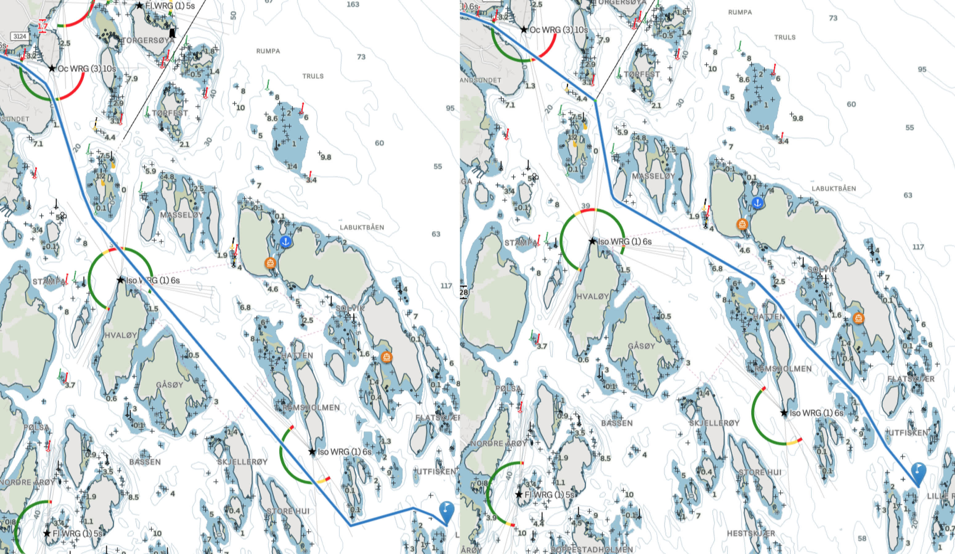
Below is an example of the old Leeway approach.

To the left: Maximum Leeway follows mostly open water, but makes several shortcuts unnecessarily close to shore. To the right: Minimum leeway is 5% shorter but follows a more challenging route.
The biggest limitation with the previous approach was that a large Leeway could route you close to shore when the shoreline was free of obstacles, marks, and buoys.
This limitation was particularly prominent in the Mediterranean – where coastlines are less complex and there are fewer marks, buoys, and obstacles to push routes away from the shore when you set a high Leeway.
For this update, Leeway as a concept has been rebuilt from scratch.
Leeway now represents the preferred navigation distance to shore or obstacles, ranging from 0 to 500 meters (0 to 1500 feet). This makes Leeway easier to understand and more predictable for you as a boater.

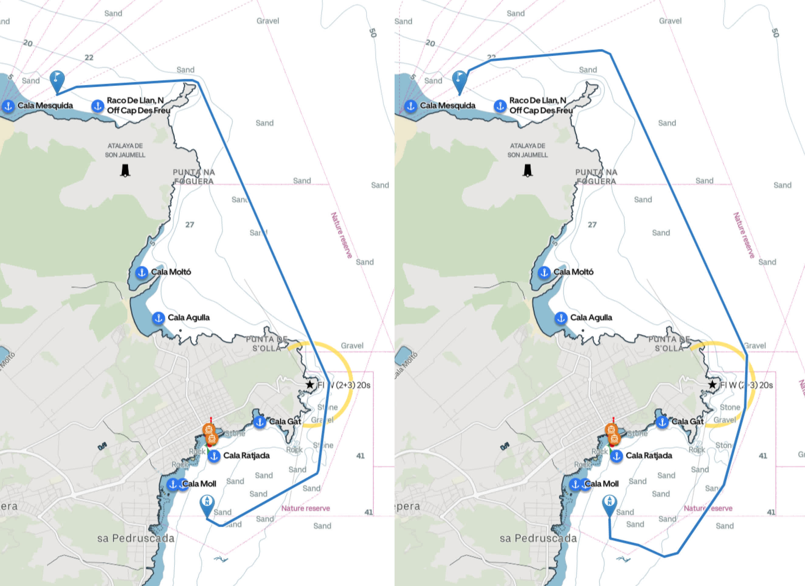
To the left: Maximum Leeway before this update. The route cuts ~50 meters away from shore before reaching the northern bay. To the right: Maximum Leeway after this update. The route stays consistently ~500 meters away from shore.
Overall, routes now have a much more consistent distance to shore. This consistency means predictable route results regardless of coastline shape, obstacles, buys, and marks.
Leeway is not the only improvement of routing in this release. Routing is also much better at deciding when to follow recommended tracks and finding passages through narrow channels with obstacles.
Start planning with Orca
So while the winter is settling in, plan some routes for next summer and let us know what you think about routing at the Orca Owner’s Club. The improvements in this week's update wouldn't be possible without your feedback, so keep it coming – we truly appreciate it!
Also, if you are longing for summer and need something to get yourself through this winter season, why not get yourself an Orca Core for Christmas? After all, it's probably the smartest upgrade you can get for your boat.


