All Articles
Better charts
November 21, 2025 • 3 min read
Better charts, performance, and improved information about updates has arrived in Orca.

A cornerstone of Orca's philosophy is that great charts should deliver accurate data and easy-to-read visuals. On top of this, electronic charts must be performant and responsive, so you can quickly explore and plan for what comes next.
This week’s update delivers on that philosophy. It introduces chart improvements, a more responsive and fluid Orca experience, plus a new way to learn about changes and updates in Orca. Here is what is new:
Better charts
This release improves the visualization of restriction zones in Orca, along with better labeling of marks, buoys, light sectors, and bridges.
Restriction Zones
Orca has always shown restriction zones in the chart, adhering closely to the traditional paper chart visualization. For a recreational boater, most restrictions in the chart do not affect how you should navigate – but there are some you should be very vigilant about.
In the latest chart release, Orca will now highlight no-entry and no-anchoring restrictions with unique symbols and shading, making them easy to spot.
No-entry zones are clearly marked with a magenta shade and a no-entry symbol.
In addition, this update introduces more textual information for restriction and information zones – both in the chart and via the Chart Info Tool.
To the left: The new chart visualization makes it easy to spot the no-anchor zone and the supplemented information. To the right: The old chart visualization, where one would need to use the Chart Info Tool to learn more about the anchorage restriction.
Better labels
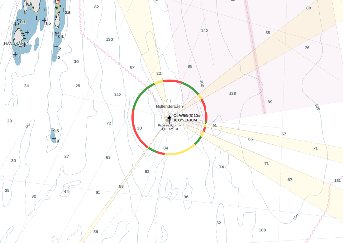
The new chart update brings improvements to label placement for marks, buoys, light sectors, and other chart elements. A highly requested and easy-to-spot improvement is that Orca now consistently shows the names of lighthouses.

Lighthouses, such as the famous Holenderbåen in the Oslofjord, are now clearly labelled with their name.
In previous chart versions, labels on marks and bridges would appear unconditionally when zooming into the map, which could result in clutter that was difficult to read. In the new update, mark, bridge, and buoy labels are laid out intelligently based on available free space in the chart. The result is an easier-to-read chart experience with less clutter.
To the left: The new chart visualization, where bridge names are intelligently shown when space is sufficient. To the right: The old visualization demonstrates overlapping bridge names that collide with other labels.
Better data
This release also contains a significant extension of high-resolution chart coverage in the Netherlands. New areas include Fluessen, Heegermeer, Slotermeer, Sneekermeer, Tjeukemeer, and other lakes and connected canals in Friesland and Groningen.
Southwards, the Veluwemeeer, Eemeer, and Gooimeer have received high-resolution bathymetry updates.
A view of the Wolderwijd with high-resolution bathymetry.
The bathymetry data in these new areas is primarily built from crowd-sourced data provided by Orca Core owners. These improvements are currently only available in the Netherlands. In the future, more areas will be added.
Better performance
A great navigation system should be responsive, and this update brings big improvements to the overall performance in Orca. The first noticeable improvement is the speed at which the Orca app starts. The Orca app now starts up to 40% faster than previous versions.
To the left: Starting Orca on an iPhone 16 is now incredibly fast. To the right: The old app version was fast, but had room for improvement.
Transitions between screens, such as opening the instrument panel, are also faster and much more fluid thanks to significant upgrades to Orca's rendering pipeline.
To the left: The latest update shows instruments quickly with smooth animations. To the right: The previous version shows signs of stutter while loading instruments. A heavy NMEA 2000 load was simulated to stress the system in this example.
Beyond the examples above, every interaction in Orca has now been improved and optimized for performance and fluidity. While responsiveness is a key part of a pleasant product experience, better performance has two important implications:
In demanding situations, speed and responsiveness can be safety-critical
Better performance means less power draw, which means Orca now uses less battery
A better way to know what is new in Orca
Orca is continuously improving through new functionality and better charts.
In the past, you could learn what was new in Orca via a Release Information Website. This website is now being retired and replaced with a dedicated experience in Orca. For Core Owners, you will now be able to learn what is new via the Core's Software Update screen. Orca App and Display 2 owners can view the release notes via Settings > Software Update.
Orca will now let you know precisely what is new in each update.
Modern boating
Orca is a navigation experience for the modern boater. It comes with incredible tools for planning and navigation that help you make more informed and better decisions at sea. Use Orca on your phone, or upgrade to an Orca Core to take your Orca experience to the next level.

Orca Core powers many of the advanced features in Orca.
If you are looking for an upgrade, look no further. Order now via the Orca Store, with free express shipping and a 30-day satisfaction guarantee.


